GPSMAP 60CSx software version 4.00
as of May 26, 2009
Download (2.13 MB)
View installation instructions and system requirements
Change History
Changes made from version 3.90 to 4.00:
- Fixed several errors in NMEA statements introduced in 3.90.
- Fixed WAAS information not showing ‘D’ in satellite bars. Error was introduced in 3.90.
- Other minor bug fixes.
Changes made from version 3.70 to 3.90:
- Added support for maps greater than 2 GB.
Changes made from version 3.60 to 3.70:
- Fix issue where bathymetric (underwater depth) lines would not show up in non-marine night color mode.
- Fix issue where tide page can show the wrong date.
- Fix shutdown when the day view calendar page has more than 9 waypoints and a point at index greater than 9 is deleted.
- Fix issue where tracklog setting was changed when unit was put into mass storage mode.
Changes made from version 3.50 to 3.60:
- Correct German translation of ‘delete all waypoints’
- Fix data card unlock failure when 2 cards of the same map set are used in one device
- Improve sun times for polar regions
- Fix issue where ETA in non motor vehicle modes can be unreasonably short
- Improve robustness of compass when it would appear uncalibrated until a power cycle
- Increase precision of distance measurement to the cursor on the map page
- Allow backlight adjustment on the track back point selection page
- Fix shutdown when editing Estonian Grid coordinates
- Correct daylight saving time for New Zealand
- Improve selection of the names of cross roads with NT maps
- Correct potential shutdown when viewing a vertical profile
Changes made from version 3.30 to 3.50:
- Change number of lines of text in the address field on map feature review page from 4 to 6.
- Improve robustness when recovering from a partial map load.
- Limit number of custom POI bitmaps to 64 to ensure enough memory resources.
- Added better compatibility with Mac computers in USB mass storage mode.
- Improved pedestrian route calculation for shortest distance method.
- Added ability to recalculate a direct goto route.
- Fix issue where MPC maps could potentially cause a shutdown.
- Address issue where nearest points search would skip some points.
- Changed datum used in the the SWEREF 99TM grid to GRS80.
- Changed datum used in the the Estonian grid to GRS80.
- Fix potential shutdown when using TOPO West 1999.
- Fix potential shutdown on track setup for data card when track log files have long file names.
- Corrected French translation for ‘Log track points’.
- Improved promptness of the turn review popup.
- Improve track log recording for sensor products to continue recording sensor data even when GPS doesn’t have a fix.
- Fix potential shutdown when propagating in a cul-de-sac across a map boundary.
- Added more time zones.
- Fix potential shutdown when clearing recent find list when custom POI with custom bitmaps are in the list.
- Add A905/D900 unlock code communication protocol.
- Make route recalculation on MPC maps behave like City Navigator maps.
- Remove lithium ion as a battery choice.
Changes made from version 3.20 to 3.30:
- Fix potential shutdown when searching UK extended postal codes.
- Ensure that all UK extended postal code search results are shown.
- Enable the Quit button function on the geocache compass page.
Changes made from version 3.10 to 3.20:
- Updated daylight saving time dates.
- Add capability for 2 wide data fields on map, compass, and highway pages.
- Add capability for 1 wide data field on map page.
- Added data card information page.
- Add selectable alarms for proximity waypoints and custom POI.
- Improve labeling and scanning of custom POI on the map page.
- Address issue where custom POI finder would erroneously produce no results.
- Add capability to see vertical profile of an autoroute using DEM topo data.
- Fixed issue with incorrect dates showing when editing the date field for Sun & Moon page and Hunt & Fish page.
- Fix issue where invalid find menu options could show when using the Auto Order feature.
- Fix issue with the Swiss grid providing incorrect coordinates.
- Fix issue where route names would be converted to upper case during editing.
- Update data card driver to support SD version 2 cards.
- Corrected problem with NMEA input that could corrupt Waypoint names in WPL sentences.
Changes made from version 3.00 to 3.10:
- Fix problem where buoy colors were drawn incorrectly.
- Improve robustness of data card tracklog XML.
- Corrected issue where some highway shields were blank.
- Prevent creation of duplicate waypoints for WPL NMEA input.
- Fix problem where last 5 custom waypoint symbols were not usable.
- Prevent propagation along roads when lock to road feature is disabled.
- Add Borneo RSO grid.
- Corrected issue where cummulative distance view on altimeter page wouldn’t show whole log.
- Allow diacritical characters in waypoint comments.
- Allow diacritical characters to transfer from Mapsource.
- Increase number of map tiles that will draw at once.
- Added capability to send custom POI waypoints in a route to Mapsource. Requires Mapsource version 6.12. Please refer to http://www.garmin.com/support/mappingsw.jsp
Changes made from version 2.90 to 3.00:
- Fixed problem of shutdown when viewing map Topo Great Britain v2.
- Improved drawing of lines for MPC maps.
- Reduced variation in battery gauge indicator.
- Fixed display scrolling issues when searching for roads.
Changes made from version 2.70 to 2.90:
- Add feature to save active track log to file on data card.
- Add ability to utilize mass storage on PC via USB connection.
- Fix NMEA output to include GPGSV sentence.
- Improve Garmin USB Mac support.
Changes made from version 2.60 to 2.70:
- Improve path nighttime color for map Topo Great Britain v2.
- Enhance layout and functionality of tide station chart information.
- Add new time zones for major cities in the U.S. and Europe.
- Improve By-Name city search to use all available maps.
- Improve layout of airport information display.
- Improve reset function of timer lap distance.
- Improve route calculation performance by setting recalculation distance farther ahead.
- Fix issue where extremely high or low altitude readings could occur when baro auto-calibration was enabled.
- Prevent Poor Satellite Reception popup from repeatedly occurring when GPS is off.
- Add GPRMB sentence to the NMEA output.
- Improve stability when using Lithium Ion Battery.
- Fix track log time stamps.
- Improve Custom POI banner display on map preview page.
- Fix issue where total ascent and total descent were incorrectly computed.
Changes made from version 2.50 to 2.60:
- Improve compatibility with nRoute PC application.
- Add compass hold level indicator.
- Improve elevation level display to show maximum values.
- Increase loadable maps to 2025.
- Improve anchor drag alarm tone so that it stays on until the user clears it with the appropriate key press.
- Improve stability of unit when user has selected a customized color scheme and is viewing tide station information.
- Improve the autozoom feature when viewing an active autoroute on the Map page. When momentarily going to the Turn Preview page and then returning to the Map page, the autozoom distance is maintained instead of defaulting to the manual zoom distance.
- Improve review of address and intersection on Map page to have full text instead of just first street.
- Enhance visibility of paths in map Topo Great Britain v2.
Changes made from version 2.40 to 2.50:
- Fixed compatibility issues with preprogrammed data cards. Some cards may not unlock properly with software version 2.40.
Installation Instructions
- It is recommended that you disable screen savers or other programs running on your PC while you go through the update process. Disruptions to the update process may render your GPS inoperable. If the transfer is interrupted, turn off the GPS and then turn it back on. Reboot your PC, go to step #9 and attempt the download again. GARMIN is not responsible for failed downloads of operating software to the GPS and factory resetting the GPS unit will fall under our Flat Rate Repair Policy.
- Click on «Download» and choose to save the file to your computer.
- Choose a location where you can easily locate the file by saving it to a location such as the «My Documents» folder or to «C:».
- Once the download is complete, go to the location where you saved the file.
- Locate the downloaded file and double-click on it. This will launch the Win-Zip Self Extractor. This program compresses the data to allow for a faster download of the needed files.
- A program window will appear asking you where to «Un-zip» the files. This is by default C:Garmin. You can change this location if you like. Be sure to note where the un-zipped files are going to allow you to find them!
- Click on the button labeled «Un-zip».
- Once the un-zip process is complete, click on the «Close» button to exit the Win-Zip Self Extractor.
- Connect your GPS to your computer using a GARMIN PC Interface cable to an open USB port. Turn the GPS on.
- If your computer asks for a driver, please see the software and installation instructions that came with your device, or download and install the USB driver from Garmin’s website at www.garmin.com.
- Open the C:Garmin folder (or other folder where you un-zipped the files), locate the file named ‘Updater’ and double click on it.
- You should see the name of your GPS device next to the ‘USB Device’ option on the Updater program window. Select the ‘USB Device’ option, then click on ‘OK’ on the Updater program window to start the data transfer.
System requirements
- IBM-compatible PC running Windows 2000 or later operating system and an available USB or Com 1, 2, 3, or 4 port.
- PC Interface Cable for your GPS unit. The PC Interface Cable may be purchased through your local Garmin distributor or ordered direct from our Online Store.

Обновление драйверов GPSMAP 60CSx вручную:
Этот встроенный драйвер GPSMAP 60CSx должен быть включен в операционную систему Windows® или доступен через обновление Windows®. Встроенные драйверы будут поддерживать основные функциональные возможности вашего GPS, но, как правило, не более расширенные функции.
Перейдите по этой ссылке, чтобы узнать, как установить эти драйверы Garmin.
Порядок выполнения автоматической загрузки и обновления:
Рекомендация: Начинающим пользователям Windows рекомендуется обновлять драйверы Garmin GPS устройства с помощью утилиты для обновления драйверов DriverDoc [DriverDoc — Продукт от Solvusoft]. Данная утилита Windows выполняет автоматическое скачивание, установку и обновление текущих драйверов 60CSx, предотвращая установку неправильного драйвера для вашей ОС.
Кроме того, при использовании DriverDoc для обновления драйверов GPS, вы также сможете обновлять все остальные драйверы на вашем ПК, используя нашу обширную базу, содержащую более 2 150 000 драйверов (пополняется ежедневно) для любых аппаратных устройств.
Установить необязательные продукты — DriverDoc (Solvusoft) | Лицензия | Политика защиты личных сведений | Условия | Удаление
![]()
60CSx Часто задаваемые вопросы относительно обновления
Какова функция драйвера GPS Garmin?
Драйверы устройств, например, разработанные Garmin специально для 60CSx, способствуют правильного взаимодействия GPS и операционной системы.
Почему большинство пользователей пропускают обновления драйверов 60CSx?
Большинство пользователей не обновляют драйверы устройств 60CSx, потому что они не хотят создавать проблемы со своим ПК.
Драйверы 60CSx работают на каких операционных системах?
Windows.
Как обновляются драйверы 60CSx?
GPSMAP 60CSx драйверы можно обновить вручную с помощью Device Manager (Диспетчера устройств) Windows или автоматически, загрузив утилиту для обновления программного обеспечения драйверов.
Проблемы технического обслуживания водителей
GPSMAP 60CSx подвержен системным ошибкам, связанным с поврежденными или устаревшими драйверами устройств. Драйверы устройств могут работать в один прекрасный день, а затем перестать работать на следующий день из-за ряда причин. Хорошей новостью является то, что драйверы принтеров могут быть обновлены для устранения любых GPS.
Найти точный драйвер для вашего аппаратного устройства, связанного с GPSMAP 60CSx, может быть чрезвычайно сложно, даже непосредственно на веб-сайте Garmin или связанного с ним производителя. Тем не менее, даже если вы хорошо найдете, устанавливаете и обновляете драйверы для GPSMAP 60CSx, вы все равно можете тратить много времени и быть очень разочарованы этим начинанием. Неверные версии драйверов вызовут больше осложнений с производительностью вашего ПК, иногда причиняя больший ущерб.
Чтобы идти в ногу со всеми необходимыми новыми обновлениями, мы предлагаем пойти с программой обновления драйверов. Хорошая служба обновления драйверов гарантирует наличие текущих совместимых драйверов и создает резервную копию всех текущих драйверов, прежде чем вносить какие-либо изменения. Файлы резервных копий драйверов обеспечивают безопасность функции отката и возможность вернуться к предыдущей версии (при необходимости).
Топ-5 драйверов GPSMAP (164 Модели)
-

130
-
135 Sounder
-
162
-
168 Sounder
-
172
Установить необязательные продукты — DriverDoc (Solvusoft) | Лицензия | Политика защиты личных сведений | Условия | Удаление
Поиск по ID
Garmin USB Drivers v.2.3.1.2 Windows XP / Vista / 7 / 8 / 8.1 / 10 32-64 bits

Подробнее о пакете драйверов:Тип: драйвер |
Драйверы USB от компании Garmin Ltd. Предназначены для установки на Windows XP, Windows Vista, Windows 7, Windows 8, Windows 8.1, Windows 10 32-64 бита.
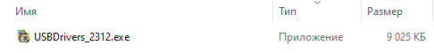
Для автоматической установки скачайте и запустите файл — USBDrivers_2312.exe.
Версии драйверов:
- grmnusb.inf — v.2.3.1.0 от 19.04.2012
- grmn0300.inf — v.3.02.0.0 от 22.07.2015
Внимание! Перед установкой драйвера Garmin USB Drivers рекомендутся удалить её старую версию. Удаление драйвера особенно необходимо — при замене оборудования или перед установкой новых версий драйверов для видеокарт. Узнать об этом подробнее можно в разделе FAQ.
Скриншот файлов архива
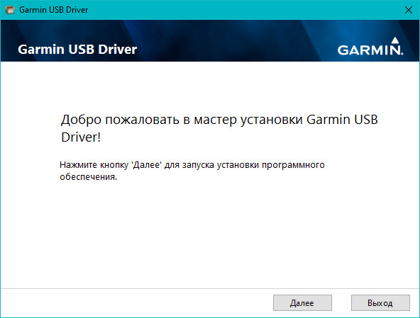
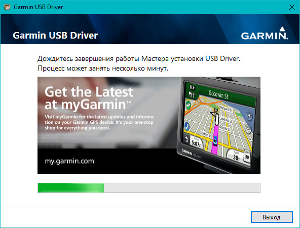
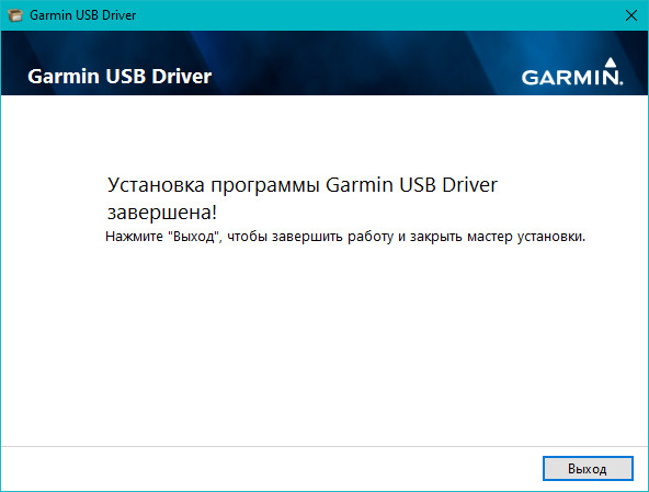
Скриншоты с установкой Garmin USB Drivers
Файлы для скачивания (информация)
Поддерживаемые устройства (ID оборудований):
Другие драйверы от Прочие устройства
Сайт не содержит материалов, защищенных авторскими правами. Все файлы взяты из открытых источников.
© 2012-2023 DriversLab | Каталог драйверов, новые драйвера для ПК, скачать бесплатно для Windows
kamtizis@mail.ru
Страница сгенерирована за 0.035378 секунд
![]()
Правила форума
Для предотврашения спама первые сообщения вновь зарегистрированных пользователей проходят ручную премодерацию.
-
dsasd
- Сообщения: 20
- Зарегистрирован: 18 ноя 2009, 21:38
драйвер для GPSmap60C
Где можно скачать драйвер для GPSmap60C
-
dsasd
- Сообщения: 20
- Зарегистрирован: 18 ноя 2009, 21:38
Re: garmin.com
Сообщение
dsasd » 10 апр 2008, 00:20
нужен драйвер для соединения компа с навигатором
-
Igor61
- Сообщения: 701
- Зарегистрирован: 26 апр 2013, 16:27
Вам же пишут-garmin.com…
Сообщение
Igor61 » 10 апр 2008, 09:33
Драйвер 2.2.1 кажется под все приборы и подходит. Выберите название своего из списка.
-
dsasd
- Сообщения: 20
- Зарегистрирован: 18 ноя 2009, 21:38
Спасибо большое.
Сообщение
dsasd » 11 апр 2008, 10:16
Видимо я еще не дорос и до чайника, ищу драйвер на garmin.com, но найти его не могу. Может я в самом деле ищу не там??? ПОМОГИТЕ!!!!
-
dsasd
- Сообщения: 20
- Зарегистрирован: 18 ноя 2009, 21:38
Re: Спасибо большое.
Сообщение
dsasd » 12 апр 2008, 23:57
у меня как всегда нестандартные проблемы….скачал драйвер «USBDrivers_221» и на половине инсталяции он остановился и выдал что-то на английском языке, а с ним у меня проблема, может он не подходит для моего «GPSmap 60C»???
-
Igor61
- Сообщения: 701
- Зарегистрирован: 26 апр 2013, 16:27
Re: Спасибо большое.
Сообщение
Igor61 » 13 апр 2008, 13:35
Сначала устанавливаете драйвер,как прибор может мешать? Тем более,что он один для большинства приборов. Что пишет на английском?
-
Igor61
- Сообщения: 701
- Зарегистрирован: 26 апр 2013, 16:27
Re: Спасибо большое.
Сообщение
Igor61 » 13 апр 2008, 13:35
Сначала устанавливаете драйвер,как прибор может мешать? Тем более,что он один для большинства приборов. Что пишет на английском?
-
dsasd
- Сообщения: 20
- Зарегистрирован: 18 ноя 2009, 21:38
Re: Спасибо большое.
Сообщение
dsasd » 20 апр 2008, 06:32
после нескольких дней мучений, всетаки драйвер установил, но прибор я всеравно не вижу, хотя программа (garmin/XImage) с прибором контактирует. Может комп не должен видеть прибор как флешку (или телефон)?
Кто сейчас на конференции
Сейчас этот форум просматривают: нет зарегистрированных пользователей и 69 гостей